Pontiac, Michigan
| City of Pontiac | |||
|---|---|---|---|
| — City — | |||
|
|||
 |
|||
| Coordinates: | |||
| Country | United States | ||
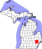
| State | Michigan | ||
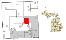
| County | Oakland | ||
| Settled | 1818 | ||
| Incorporated | 1861 | ||
| Government | |||
| - Type | Council-Strong Mayor | ||
| - Mayor | Leon Jukowski | ||
| Area | |||
| - Total | 20.2 sq mi (52.3 km2) | ||
| - Land | 20.0 sq mi (51.8 km2) | ||
| - Water | 0.2 sq mi (0.6 km2) | ||
| Elevation | 922 ft (281 m) | ||
| Population (2000) | |||
| - Total | 66,337 | ||
| - Density | 3,318.2/sq mi (1,281.2/km2) | ||
| Time zone | Eastern (EST) (UTC-5) | ||
| - Summer (DST) | EDT (UTC-4) | ||
| ZIP codes | 48340-48343 | ||
| Area code(s) | 248 | ||
| FIPS code | 26-65440[1] | ||
| GNIS feature ID | 0635224[2] | ||
| Website | http://www.pontiac.mi.us | ||
Pontiac is a city in the U.S. state of Michigan named after the Ottawa Chief Pontiac. As of the 2000 census, the city had a total population of 66,337. It is the county seat of Oakland County[3]. Considered a satellite city of Detroit, it is surrounded by affluent Metro Detroit suburbs.
The city is best-known for its General Motors manufacturing plants (GM's primary truck plant was formerly in Pontiac) and the GM automobile brand, Pontiac, which was first produced in and named after the city. Also of note is the Pontiac Silverdome, the stadium that hosted the Detroit Lions from 1975 until 2002 when they moved back to Downtown Detroit.
On February 20, 2009 the State of Michigan placed the city into receivership[4], and the Department of Treasury appointed Fred Leeb the city's emergency financial manager in March 2009.[5]
Contents |
Geography
According to the United States Census Bureau, the city has a total area of 20.2 square miles (52.3 km²), of which, 20.0 square miles (51.8 km²) of it is land and 0.2 square miles (0.6 km²) of it (1.09%) is water.
The city is bounded by the City of Auburn Hills to the east and north, the City of Lake Angelus to the north, Waterford Township to the west, and Bloomfield Township to the south.
The defunct civil township, which was known as Pontiac Township, initially included what are now the cities of Pontiac, Lake Angelus, and Auburn Hills. The township incorporated as the City of Auburn Hills in 1983. Although the township no longer exists as a civil entity, it is still used as a survey township for land use purposes.
Demographics
As of the census[1] of 2000, there were 66,337 people, 24,234 households, and 15,267 families residing in the city. The population density was 3,318.2 per square mile (1,281.3/km²). There were 26,336 housing units at an average density of 1,317.3/sq mi (508.7/km²). The racial makeup of the city was 39.09% White, 47.92% African American, 0.58% Native American, 2.40% Asian, 0.04% Pacific Islander, 6.47% from other races, and 3.50% from two or more races. Hispanic or Latino of any race were 12.76% of the population.
There were 24,234 households out of which 33.9% had children under the age of 18 living with them, 31.5% were married couples living together, 25.2% had a female householder with no husband present, and 37.0% were non-families. 29.4% of all households were made up of individuals and 8.0% had someone living alone who was 65 years of age or older. The average household size was 2.68 and the average family size was 3.32.
In the city the population was spread out with 30.6% under the age of 18, 10.3% from 18 to 24, 32.3% from 25 to 44, 18.3% from 45 to 64, and 8.5% who were 65 years of age or older. The median age was 30 years. For every 100 females there were 94.8 males. For every 100 females age 18 and over, there were 90.3 males.
The median income for a household in the city was $31,207, and the median income for a family was $36,391. Males had a median income of $31,961 versus $24,765 for females. The per capita income for the city was $15,842. About 18.0% of families and 22.1% of the population were below the poverty line, including 29.3% of those under age 18 and 15.7% of those age 65 or over.
Education
Residents are zoned to the School District of the City of Pontiac. The district runs one main high school, Pontiac High School. The other main high school, Pontiac Central High School closed in 2009.[6] In recent years, many residents of southern Pontiac have begun sending their kids to Bloomfield Hills Schools and Waterford Schools causing a notable swell in the number of children attending those high schools.
The district currently serves to about 6200 students.
There are four charter schools in Pontiac which offer a school choice to residents of Pontiac and the surrounding cities. The four charter schools are: Pontiac Academy for Excellence (K-12), Arts and Technology Academy, Walton Charter, and Great Lakes Academy.
History
Early expeditions into the land north of Detroit described the area as having "extreme sterility and barrenness." Developments and exploration were soon to prove that report false.
The first settlers arrived in what is now the city of Pontiac in 1818. Two years later there were enough people there to form a village named after the famous Indian Chief who had made his headquarters in the area only a few years before. Pontiac was Michigan's first inland settlement.
The village was officially recognized by the state legislature in 1837 and it incorporated as a city in 1861. From the beginning, Pontiac's central location served it well. It attracted professional people, including doctors and lawyers, and soon also became a center of industry. The city became the location of choice for woolen and grist mills which made use of the Clinton River as a power source. With the coming of the railroad through the downtown area in 1844, Pontiac's progress and success were assured.
Abundant natural resources led to the establishment of several carriage manufacturing companies, all of which were thriving at the turn of the century when the first self-propelled vehicles were introduced. Pontiac quickly became a capital of the new automotive industry. As the small, "horseless carriage" manufacturers became consolidated under the mantle of the General Motors Corporation, Pontiac grew as the industry grew, suffering the same setback as other cities during depression years of the 1930s. In the boom years following World War II, Pontiac was at the forefront of growth in affluent Oakland County.
In the 60s and 70s came urban renewal in an attempt to revitalize the downtown area. In 1970s, construction began on the "Pontiac Plan." This plan included the Phoenix Center, two office buildings and a high rise residential complex. The "Pontiac Plan" was a vision of Pontiac business owner C. Don Davidson.
While the city joined many others in experiencing a slowdown of retail business in the downtown area in the '60s and '70s, a renewed spirit of optimism has taken over as Pontiac moves forward in the new century.
Culture
Regionally, the city is known for the Arts, Beats and Eats Festival, a widely attended summer festival featuring an art show, musical concert venues (including The Crofoot), and a sampling of food from numerous regional restaurants.
The city is at the north end of the famous Woodward Avenue, known in the 1950s and 1960s as being popular with young people who would "cruise" and drag-race their hot-rods in the area. Pontiac participates in the annual Woodward Dream Cruise, an event celebrating Woodward's hot-rod history, stretching from Pontiac to Detroit.
The city is also host to 2 of the nation's renowned Haunted Houses: The Realm of Darkness and Erebus. The Realm of Darkness has in previous years been chosen as America's Best Haunted House. Erebus currently holds the world record for "Largest Haunted House" at 4 stories high.
Pontiac is one of the cities in Michigan being used to film the 2010 remake of the film Red Dawn, recreating Spokane, Washington.
Pontiac is home to the Michigan Fallen Heroes Memorial[7]
Transportation
Amtrak, the national passenger rail system, operates its Wolverine from Pontiac to Chicago via Detroit and Battle Creek, Michigan. Service is three times daily, both arriving and departing.
Commuter rail service was once provided by Grand Trunk Western Railroad (GTW) and later Southeastern Michigan Transportation Authority (SEMTA) from Pontiac to downtown Detroit. This service ended on October 17, 1983, after subsidies were discontinued. Efforts continue to this day to restore such commuter service.
Class one freight rail service is provided by Canadian National Railway (CN), which also operates a large classification yard in Pontiac serving the local auto industry.
Oakland County International Airport services the city and surrounding areas with commuter air service.
Suburban Mobility Authority for Regional Transportation (SMART) operates local and regional bus transit.
The major thoroughfares in the city are: Woodward Avenue (M-1), Huron Street (M-59), and Telegraph Road (US 24). Portions of Woodward Avenue were once known as "Saginaw Street" and "Wide Track Drive" (the portion of Saginaw Street that runs through the downtown business district remains under that name).
|
|
I-75 provides a quick connection northwest to nearby Flint. Detroit is to the south. |
|
|
I-75 Business Loop routes through Pontiac. |
|
|
US-24 ends north of Pontiac in at I-75. Southbound, US 24 serves suburban Detroit and Monroe before crossing into Ohio. |
|
|
BUS US 24 serves local business traffic through the city. |
|
|
M-1 (Woodward Ave.) northbound ends in Pontiac. Southbound, the highway routes to directly to downtown Detroit. |
|
|
M-24 (Lapeer Road) southbound ends in Auburn Hills at I-75. Northbound, the highway routes to Lapeer. Note: M-24 does not intersect with US 24. |
|
|
M-59 routes west to Howell and east to Utica and several other Detroit suburbs. |
Government
- State officials
- Governor Jennifer Granholm (D)
- State Senator Michael Bishop (R) - 12th State Senate District - current Senate Majority Leader
- State Representative Tim Melton (D) - 29th State House District
- Federal officials
See also
- Images of metropolitan Detroit
- The Crofoot building in Pontiac
- Saginaw Trail
References
- ↑ 1.0 1.1 "American FactFinder". United States Census Bureau. http://factfinder.census.gov. Retrieved 2008-01-31.
- ↑ U.S. Geological Survey Geographic Names Information System: Pontiac, Michigan
- ↑ "Find a County". National Association of Counties. http://www.naco.org/Template.cfm?Section=Find_a_County&Template=/cffiles/counties/usamap.cfm. Retrieved 2008-01-31.
- ↑ State Puts Pontiac In Receivership, WWJ Newsradio 950, published 25 February 2009 10:27AM
- ↑ Financial Manager Appointed for Pontiac, WJBK Fox 2 Detroit, published 19 Mar 2009, 5:52 PM EDT
- ↑ http://www.theoaklandpress.com/articles/2008/12/17/news/local_news/doc4948cde5991a8809807968.txt
- ↑ http://www.michiganfallenheroesmemorial.com/contact.html
External links
- Official City Website
- History of the City
- The Oakland County
- PONTIAC MASTER PLAN
EXECUTIVE SUMMARY[1]
|
||||||||||||||||||||||||||
|
|||||||||||||||||||||||||||||||||||
|
||||||||||||||||||||||